Britain has a rich history of coal mining, with historical records tracing it back to at least the 12th Century, though its origins likely predate even this period. Initially, coal and mineral rights were vested with landowners, resulting in limited documentation until the enactment of the 1872 Coal Mines Regulation Act, which mandated the production of mine plans upon abandonment.
The Coal Authority (CA) maintains a comprehensive archive encompassing over 170,000 mine entries across the UK. These records are founded on abandonment plans, geological data, and ordnance survey information. The Coal Authority Interactive Viewer offers a regional-scale platform to access and explore CA-held data. This tool allows users to investigate the locations of recorded mine entries and access pertinent details such as entry type (e.g., shaft or adit), location reliability, and whether any remediation has been undertaken.
Nonetheless, the CA’s extensive records cover only a fraction of the actual number of mine entries. Many more remain undocumented, including both mine shafts and bell pits. As the name implies, Bell pits feature a bell-shaped profile, narrowing at the surface and widening at the base where extraction of coal or other minerals of interest occurred. This method endured for centuries but was largely phased out in the mid-19th Century when more efficient techniques were introduced. Bell pits were short-lived and abandoned when miners reached a safe maximum depth, often leaving a pockmarked landscape due to their proximity.
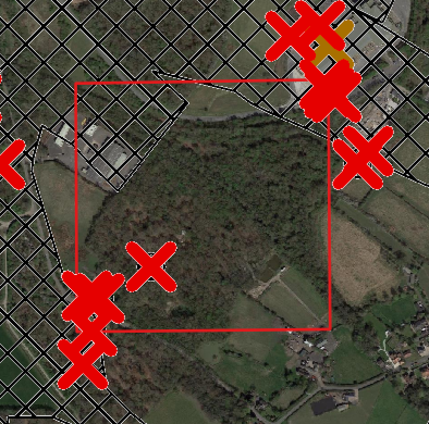
Detecting unrecorded mine entries presents challenges, often necessitating invasive investigations to confirm their presence. Recently, GRM has employed LIDAR imaging (Light Detection and Ranging) in Coal Mining Risk Assessments to identify surface features potentially linked to historical mining.
LIDAR uses light pulses to measure distances to objects on or near the Earth’s surface. Due to the small spacing between points, it can be very effective at determining the ground profile even where the ground is obscured. The two images below show this in practice. The LIDAR image on the right reveals circular variations in the ground profile that are not visible in the aerial image. These could potentially represent unrecorded bell pit mine workings.
While LIDAR may not be universally applicable, such on sites which are heavily developed with buildings, we consider it to be a valuable tool for risk assessors seeking to identify potential hazards in historic coal mining regions, and is especially useful in areas of open ground or on sites where there is heavy vegetation and small features may be difficult to see.
GRM has a wealth of experience and expertise in the mining sector, indeed it is something of a specialism given the background of our two founding Directors. We continue to work with a range of clients from large commercial developments to private homeowners looking to build or extend properties.
If you have any development or construction projects, then please get in touch to find out how we can help save both time and costs. Please use your main point of contact at GRM or for new enquiries email richard.upton@grm-uk.com or call 01283 551249.